Empower your Engineering
GIS should empower your engineering teams, but many solutions lack flexibility and/or scalability, resulting in slower rollouts and difficult strategic decisions. Marlin offers a unique approach to modelling your physical network to enable faster insights and productivity throughout the whole network lifecycle from
planning, design, build, operate and support.
Discover how Marlin GIS empowers your Engineering: faster planning, better insights, easy redlining from the field – even for millions of subscribers and complex architecture networks!
How?
The Power of Marlin
Flexible Datamodel
The datamodel approach of Marlin combines the benefits of GIS with the power of database. The network is reduced to nodes and edges. All intelligence of connections / connectivity / containment / … is provided through our datamodel.
The Marlin Approach enables a scalable GIS solution for millions of fibers and subscribers.
Dynamic Views
Dynamic Views enable the same object to be inspected in several views: geographic, trench cross-section, schematical, … By hovering and clicking on your network elements, you can fully browse and understand your network.
The powerful visualisations are generated on-the-fly: no need for manual corrections, the schematics are always up-to-date.
Enterprise Editing
Your network is continuously maintained/designed/built by several teams.
Marlin offers enterprise editing to prevent conflicts and offers undo/rollback/review capabilities.
Try and review several designs before publishing the information to the teams of engineering/build.
Integrate & Adapt
A powerful API and open datamodel allow your teams to use the accurate inventory for other solutions, processes and teams.
Marlin can be configured through a low-code environment by your and our team.
Create new workflows, provide templates,
edit schematics, …

FOcus on data quality
Workflow automation
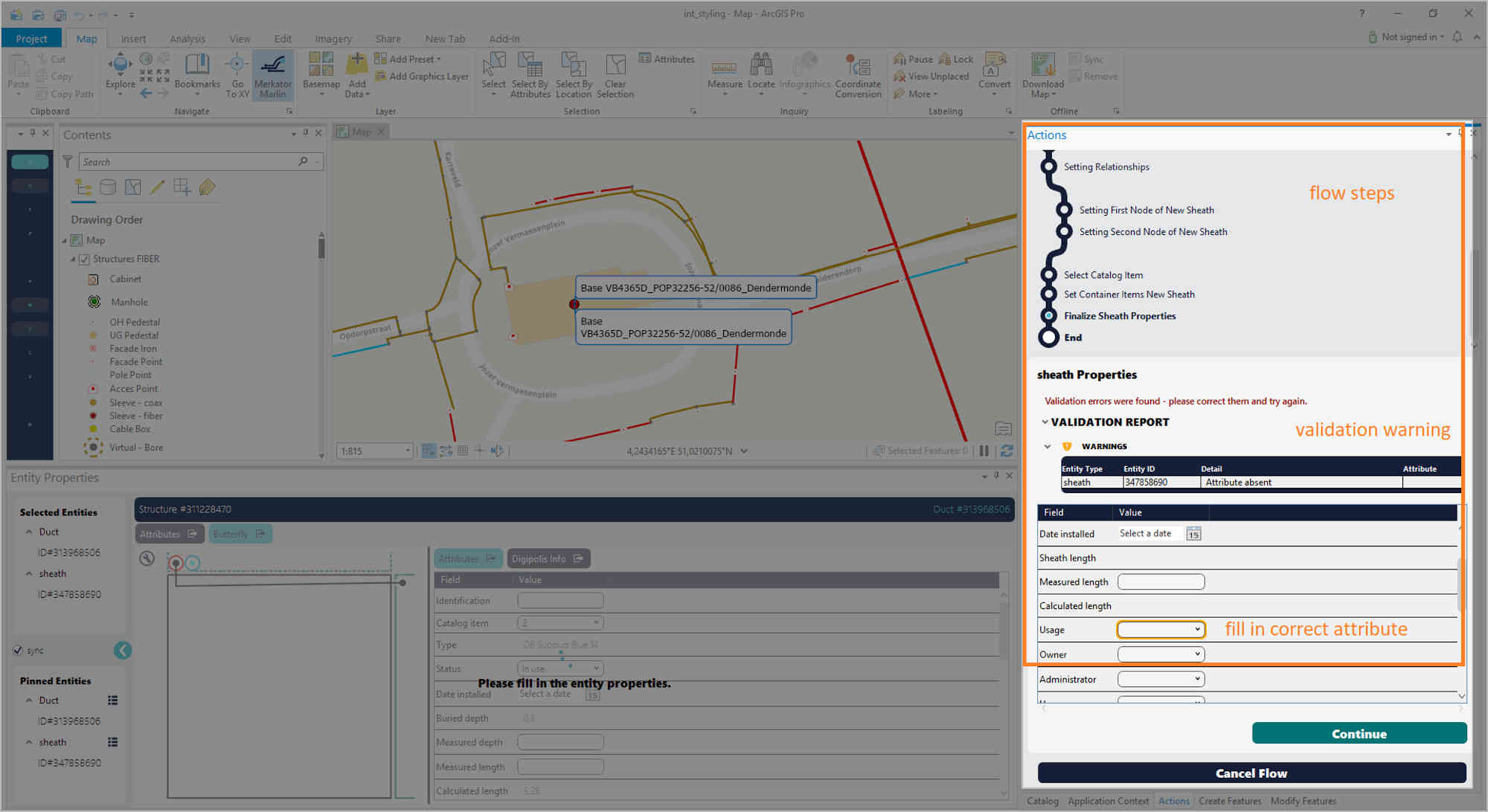
Marlin guides the users when editing asset information by providing a step-by-step process and validation warnings to prevent human errors.
Back-end services can be enabled to automate connectivity when designing large fibre cables through several manholes, even inside the building. This automation saves a huge amount of time and ensures high-quality data.
An intuitive user-interface makes the geospatial inventory easy and fun to use.
logical, geoschematical, topological views
View your network as never before
Marlin offers full search, query, inspect, design and documentation capabilities. The representation of your physical assets enable your teams to view and understand your network.
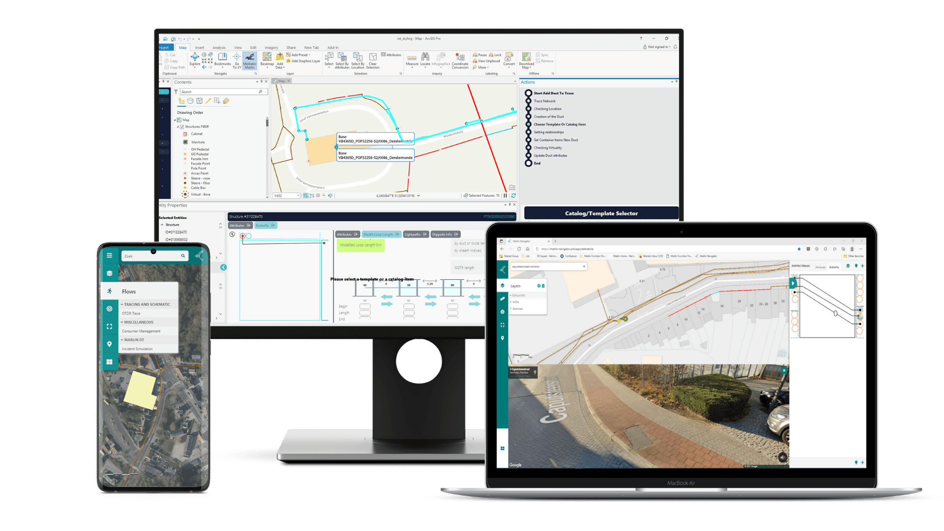
Marlin offers a fully connected outside plant & inside plant network documentation. Visualize complex splicing diagrams on your desktop, mobile and browser and prepare for printing.
Click through trenches, cross-sections, ducts, cables, fibers, splices, … and discover the full network.


esri arcgis pro & server
Esri Foundation
Marlin is deeply integrated to the Esri Foundation to provide both desktop, web and mobile views on your telecom network:
– Built on top of Esri ArcGIS Pro
– In conjunction with Esri Utility Network
– Powered by Esri ArcGIS Enterprise
Merkator develops Marlin and is a silver partner of Esri.
testimonials
What our customers love about Marlin
Marlin Digital Twin solutions
Marlin is Unique
High Data Quality
Marlin inventory relies strongly on the database. Users are guided by Workflows when editing data, and validation warnings are in place to enable high quality data input.
High-quality inventory allows for easy browsing, and generating complex visuals on the fly.
Correlate Physical & Active
Marlin and Networkmining are built by the same team and this offers a unique integration to correlate physical & active network inventory.
If your teams of operations need an accurate inventory and documentation of your layer 1 and 2 network, we offer a fully integrated Networkmining solution.
Built by Telecom Engineers
The Marlin solution is built by geospatial experts and telecom engineers to finally create a scalable, flexible, next-generation inventory solution.
Easy to integrate, easy to use, easy to maintain.
We are close to our customers, and provide excellent support.
Built for Telecom and GIS Experts
MarlinDT Solutions are created by a team with years of experience in Utitlity Networks, GIS and Telecommunications. Our frustration with the available solutions led to the development of our own next-generation inventory solution. We stay strongly connected to our customers and continue in our vision for better networks, efficient operations all around the world.
our software values
Next Generation Architecture
MarlinDT Solutions are easily scalable in complex enterprise environments. Our customers love that we are the inverse of a black box: you can have access to (y)our data, the datamodel is flexible, a powerful API enables your teams to fully integrate into your OSS/BSS eco-system.
Next Generation Telecom Inventory deserves a Next Generation Software Architecture!

Our software, your data

Connects to your eco-system

Customisable

Modern UI/UX

Scalable

Modular
Subscribe and follow
Stay up-to-date
Subscribe to learn more from our customers and partners and how they enabled operational excellence thanks to the innovations of Marlin Digital Twin.
Get whitepapers and invations to our online and physical events.
Or just follow us on the socials!
